Worcestershire Record No. 24 April 2008 pp. 34-35
LEIGH & CRADLEY BROOK FLOOD JULY 20TH 2007
Garth Lowe
This event would appear to be one of the most severe since another documented
flood in 1852. During the intervening years there have been other times when
this brook badly overflowed its banks, such as the Easter flood of 1998, when a
total of 81.8 mm (3.2 ins.) fell at Old Storridge, over the 8th and 9th April,
but did not rise to quite the same peak as this event.
The spring had started with a glorious April with only half an inch of rain
recorded, but from the second week in May something akin to monsoon conditions
set in, and by the start of this event a total of 337 mm (13.25 ins.) had fallen
since May 6th. This resulted in the land being completely saturated, so that all
this extra heavy continuous rain went straight into the nearest streams. This
extremely unusual wet spell left the countryside looking like it does in the
depths of winter, with muddy conditions everywhere, and had the writer
continuously wearing wellingtons, when out walking.
The fact that these three months totalled up an incredible 65% of the annual
average rainfall, made it look as if the whole years rainfall would eventually
be a record. This in fact did not happen, when rainfall fell back to less than
normal from Aug. to Dec. and the year although a wet one at 957.5 mm, did not
pass the record for Old Storridge of 978.6 mm in 2000. The 40 year average was
726.5 mm up to 2002, but with all the years included to 2007, this has changed
to 731.9 mm from 1962-2007.
The Meteorological Office had for some days before July 19th, been
forecasting falls of four or more inches of rain and they proved to be exactly
right in their predictions. Following this major event, an enquiry to an ongoing
local study into rainfall in the Malvern area run by a Mr Frank Hill, found that
the upper Leigh Brook catchment had four recording sites. Each rain gauge had
recorded over four inches as a total amount for the period, with one site having
just less than five inches! All these sites were from Old Storridge to Colwall,
and it was inevitable that these sorts of figures would cause untold damage all
along the watercourse. One small relieving fact was that the brook reached its
peak before darkness fell, and those having to escape inundation, were able to
leave their homes in daylight.
The fact that this event was on a Friday, meant numerous people were at work
and children were at school, leading to many having great difficulty returning
home, and some even having to find alternative accommodation for the night.
Severe road congestion took place where the brook flowed over the busy A4103 in
Cradley, instead of under it, causing many motorists to be stranded for the
night!
Vehicles were abandoned all over the area; some had to be left in the
floodwater, when the engines died. At Stiffords Bridge, on the A4103, in Cradley
one car floated up and was left suspended on a low wall. Much to everyone’s
surprise this car started perfectly well after the flood and it was driven away!
At Mousehole Bridge, on the Alfrick and Suckley Parish boundary, a similar thing
happened when another abandoned 4x4 vehicle broke down and was later washed a
hundred yards across a large field by the force of the rising waters.
In Old Storridge one kind family, when they were prevented from getting home,
gave their house to the flood victims from a brookside cottage called
Nightingale Bower. In 1998 at this same cottage, which is situated at the end of
the Knapp and Papermill Reserve, the floodwater removed the domestic gas tank
and swept it a half a mile, to eventually leave it upright on Pivany Bridge also
in the reserve. It was then eventually replaced on a firmer concrete base but
even this was not enough in the latest flood. It was eventually lifted including
the base, and taken a shorter distance leaving it just below the old ford, but
on its side this time. It was eventually removed, but the concrete base was left
for future passers by to guess as to its origin, in this remote part of the
valley.
This watercourse also passes through the older part of Cradley village, where
it is actually called the Cradley Brook or an even older name was the River
Rundle! Here it was the half timbered village shop and post office that suffered
the worst with water entering the store, unheard of before in living memory. On
the opposite side of the village near the end of Chapel Lane, other dwellings
were badly damaged.
Numerous other buildings down the length of the brook were flooded out and
also brought out the fact just how many public houses are close to the stream.
These were the Cliffey Arms at Mathon, which was closed at the time, the Red
Lion and the Prancing Pony at Stiffords Bridge. The Red Lion was hit very badly
and was unable to be opened until after Christmas. Its nearby inn was luckier in
only having eight or so inches with the cellar flooded, and was able to open
much earlier. Another property opposite the Red Lion also suffered when a
retaining wall collapsed affecting the structure of the building.
Although there are numerous road bridge crossings over this watercourse, only
one suffered partial damage. This was an old stone bridge on a narrow lane near
to Beanhouse Mill, where half the down stream parapet was flattened by the force
of the water. All the other road bridges were overwhelmed but stood up to the
onslaught, although none of them were passable at the height of the flood. One
footbridge was lifted off its foundations and tipped into the streambed near
Nightingale Bower, and another wooden footbridge was washed away at Linley
Green, but this was on a swollen tributary of the Leigh Brook. A number of other
footbridges down the length of this turbulent brook thankfully did survive, but
had quantities of debris piled up on them.
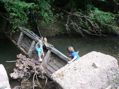
In the Knapp and Papermill Nature Reserve in Alfrick, just a few short hours
of the actual flood was enough to change many parts of the brook. In some places
the bank was washed away, and in others such as just below the weir, stones were
scoured from the bed by the turbulence over the weir and left as a new feature,
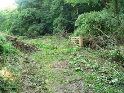
some two to three feet higher than before. Gates along the main pathway adjacent
to the stream were completely removed taking the gateposts with them, some to be
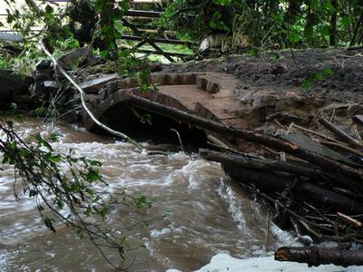
left high and dry elsewhere and recovered afterwards. Pivany Bridge itself was
badly damaged this time, when the force of the water peeled off the upstream
parapet stones and then in places took the two arches down to the single
original brick archway. A huge tree trunk had to be removed from the bridge
before an inspection could take place. It was passable after the flood but
pedestrians had to keep to the centre of the bridge.
Historically the watermills always got hit in floods and this time was no
exception. Beanhouse Mill in Cradley suffered badly, and being rather set apart,
the occupants had to struggle vainly with the rising waters. Tundridge Mill site
in Suckley faired much better following the construction of a flood defence
following the 1998 flood. In the 1852 flood here, a report stated “chairs were
left hanging on bacon hooks in the beams!”
Bridges Stone Mill near Alfrick Pound also suffered, with water getting in
the Mill itself, now converted to a dwelling. The old Mill House nearby suffered
badly and its elderly lady resident had to move to the converted Clover Mill
nearby, also originally part of this mill complex. Parts of the adjoining stone
garden walls of the garden were demolished above the bridge, and the excess
floodwater that was unable to pass under the single archway of the road bridge,
poured down the drive from the Mill. This had the resulting effect of lifting
very large patches of complete tarmac, leaving them as a temporary hindrance in
the highway. Both the brick gate posts were flattened and the post box
containing some letters, which had been posted earlier, was left at a drunken
angle. The letters were not recovered!
The Brook Cottage just a little further downstream also flooded, when the low
wall built to keep the waters out after the 1998 flood, was flattened. This was
later reconstructed to try and minimise the force of future floodwater against
it. Continuing further, Hopton Court also had an ingress of water, but suffered
no major damage.
Major flooding also occurred near Leigh Church, with five houses being
damaged around the road bridge area. One garden had the greenhouse swept away,
and it was reported that although some properties here were flooded in the 1998
event, one property had not as far as the residents knew, been inundated since
the 1852 flood.
This local flood was of course only a small part of widespread devastation,
with other parts of the county and its neighbours recording similar
catastrophes. This was the writer’s worst flooding event here in over sixty
five years of being in the parish and wonders if this was anything to do with
climate change! The only hope is it will not be witnessed again in his lifetime.
 |
 |
| Pivany Bridge Due for repair in Summer 2008, the
bridge was badly damaged when the force of the water peeled off the
upstream parapet stones and then in places took the tow arches down to
the single original brick archway © Garth Lowe |
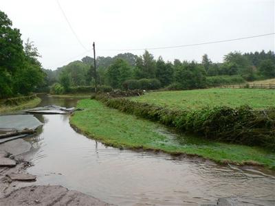
Bridges Stone Mill The flood waters were
too great to go under the road bridge, so came out from the entrance to
the mill and lifted up sheets of tarmac
© Garth Lowe |
 |
 |
Knapp footbridge It was just usable until
taken away!
© Garth Lowe |
Big Meadow on the Knapp & Papermill Reserve. This is
where the floods swept the gates open wide
© Garth Lowe |