Worcestershire Record No. 24 April 2008 pp. 7-9
A SURVEY OF POLLARD TREES IN WICHENFORD PARISH
Jane Field
The Pollard Tree Survey of Wichenford Parish is at last complete and, as I
have since learnt that it was the first of its kind, I thought it might be good
to put a few findings on paper in the hope of encouraging others to make a
similar survey of their parish. It would be particularly exciting if surveys
were done in parishes neighbouring Wichenford viz., Little Witley, Holt, Grimley,
Hallow, St John in Bedwardine, Broadwas, Cotheridge and Martley, as every lane
leading out of our parish has its pollards: these are mostly of oak, but some
ash as well. If we could put together a large area study we might learn much
more about these amazing veteran trees and their place in history.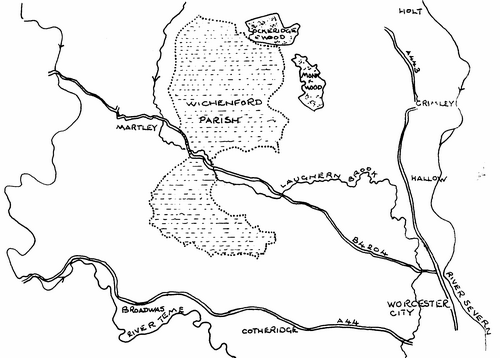
Wichenford parish is in the western Vale of the Severn and to the east of the
River Teme and it's an oddly shaped parish covering approximately 5.0 sq. miles
(c.3,200 acres). In spite of its relatively small size however, it's only fair
to say that the pollard survey did take about three years to complete. The main
reason for this is that the trees had to be found and, as Wichenford is a
place of hills, hollows, hedges, woods, streams, ponds and meandering lanes, to
do this it was necessary to cover all of the parish .... methodically ..... on
foot .... twice. It's no good assuming where pollards might be, or climbing one
and looking through binoculars, they can be prostrate in ponds, deep in ivy
cover or camouflaged in briars. It was necessary to visit every pond, walk every
hedge and investigate every wood. Pollards are not usually found within woods,
but assumptions are dangerous: the wood might be later than the tree.
The discovery of trees and plotting their position on a map had to be done in
the winter/early spring months as it can be impossible to see them when the
countryside is in abundant leaf, with prolific undergrowth. I found that wet
and/or windy days were totally impractical, much of the winter in fact, and my
own free days were few: the time available for surveying was surprisingly
limited. Two of us from the Wichenford Local Heritage Group tried to synchronise
busy lives, but failed so I did the study alone.
I found it most expedient to take an A4 photocopied map on my excursions
(1:50,000 scale), to act as a rough copy. Before setting out landmarks were
copied on to this map if not already there: the position of for example, the
church, a farm, overhead power lines, streams or ponds, in relation to
footpaths, were invaluable in the field. Another map, the master copy, always
stayed at home so if disaster should befall only one day's information was lost.
The day's discoveries were always transcribed to the master map as soon as
possible on return. It proved useful to colour the area of each day's search so
that the same ground was not walked twice: memory can blur from one winter to
the next. Never throw your field maps away, however scruffy, and always date
every scrap of paper you use. I guarantee that, however thorough you are, you
will need to refer back to them.
I would never have believed that in a relatively small parish like Wichenford
I could have got lost, but I did, a number of times, usually when the route of
footpaths was unclear or blocked, or hedges had been removed: it was then that
landmarks were essential.
A variety of waterproof coloured pens are useful if you plan to record more
than one species of tree. I started out to do a survey of oak pollards, but ash,
lime and alder soon got included; not willow because there are hundreds of them
and they need a study of their own. A brightly coloured pencil with a rubber on
the end was useful. Wichenford is littered with lost autumn-leaf coloured
pencils; I am a slow learner! A compass might be useful with no guiding sun and
a pair of binoculars proved their worth for finding landmarks.
It's probably fair to say that this first foray took longer than the second,
measuring and recording stage because some days I would walk miles and only find
one pollard. However, although it may appear to take more time, I would highly
recommend doing a survey in two stages for the following reasons. With your
distribution map it is possible to plan which groups of trees can be recorded on
the same visit, devise the most efficient route to take in the greatest number,
and be specific about your plans when asking permission from landowners - thanks
to all of them: they were really helpful. It is also possible to assess (usually
very unreliably) just how long you will be away from home. The second visit also
involved carrying more equipment, so it's good to know how far and where to.
When all (?) the trees are plotted on a map it is possible assign a number to
each, which is essential for identification on the second visit. This sounds
efficient but proved to be fraught with complications when additional trees were
found!
A second visit gives another chance to find those pollards you have missed
first time round, and double-check for correct positioning. I was amazed how
many I missed. Maybe this is where two pairs of eyes would be better than one;
it's according to how you work best. Counting pollards, although exciting, is
not easy: sometimes a long chat with the tree is necessary to decide whether it
really is a pollard. You will become painfully impaled on lethal thorns, trapped
in 'Gordian knots' of undergrowth, lose footing to roll down banks or fall into
ditches, tumble from slippery stiles and get bogged down in mud, so dress
accordingly! Do be cautious though, ...... one slip, miles from anywhere,
......... a mobile phone might be useful.
On the second visit I took the same A4 map as on the first, to double-check
positions of trees and recap on notes. Other equipment included a camera; a
hand-held Global Positioning System (more on this below) with spare batteries, a
fabric tape for measuring the girth of trees and a metal extendable tape for
measuring bole height. The overall height of the tree was estimated from a
distance, sighting with a pencil the multiples of bole height in the height of
the tree. To avoid taking lots of pieces of paper with me I summarised the
pro-forma on which each tree is recorded, putting main headings, for example
'girth', 'bole height', 'state of trunk', 'twig growth', 'number of branches',
'habitat', etc., at the top of the sheet and the tree identification number down
the side, leaving a small space for notes on each tree. In this way the vital
statistics of about thirty trees could be recorded using both sides of a single
sheet, and transcribed at home. Again, date and carefully preserve all rough
notes.
The Global Positioning System (GPS) was, I thought, an accurate and
fool-proof device which was universally accepted, and my ten figure reference
for each tree looked really impressive: ample reward for just pressing a button.
Not so ...... beware! I stood conscientiously in the freezing cold waiting for
the thing to find its satellites and settle on its final figures, only to
discover that when these were entered into a computer programme later (by
someone skilled at same) trees that should be in hedges sometimes appeared in
the middle of fields. It seemed that the GPS could get confused by tree cover,
and maybe other things as well! Hours were spent later, with the aid of
my rough field maps, and some checking on foot, plotting the trees' precise
positions onto aerial photographs. Never place implicit faith in technology!
Other tips worth passing on are to complete tree record forms with a ball
point, rather than a felt, pen if using both sides of 80 gm. (saving trees)
paper, so that these can be scanned for computer records; don't cross reference
information between record forms as each needs to stand on its own in the data
bank; if there is more than one photograph per tree each should be given its own
'a', 'b', 'c', etc. reference number, together with the tree number, for
specific photograph identification. When taking photographs try to avoid too
much contrast (eg. bright sky, dark hedge): this uses up more computer file
space. Avoid using colour coding on record sheets: colour scanning fills
computer files more rapidly. Had I been really clever I would have created my
data bank as I went along!
A parish pollard survey is a challenge, but well worth it. Wichenford parish
yielded 229 oak pollards, 55 ash, 16 lime and 1 alder, bounteous history
lessons and (sometime soon) a book: reward indeed!